Bayash
Bayash Project
Key highlights:
- The project area includes 7 exploration blocks (15.6 km2);
- The Project is located within Kalba-Narym Rare Element Pegmatitic Belt well known for its tantalum, niobium, beryllium and tin deposits mined during the Soviet time;
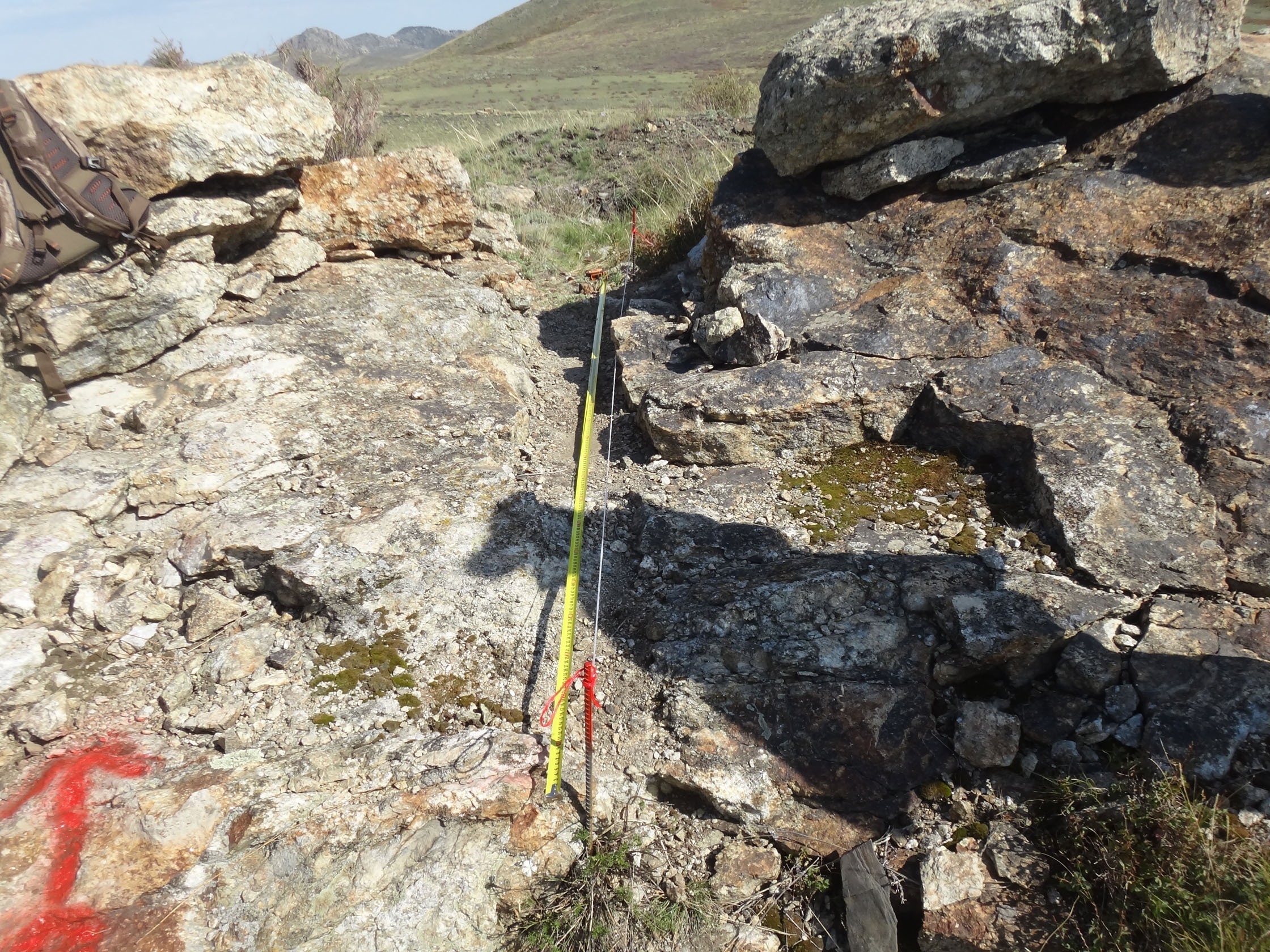
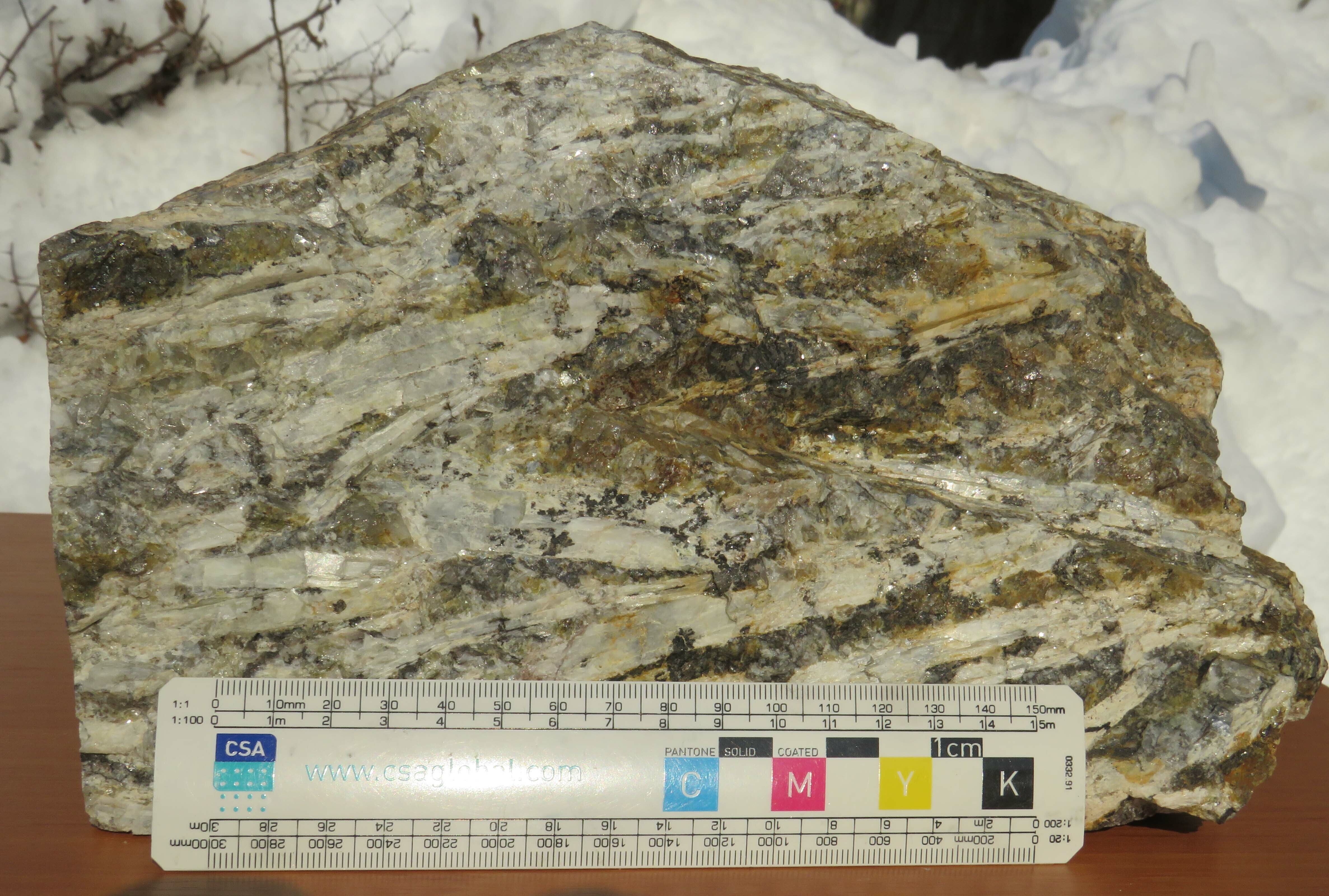
- High-grade lithium rare element pegmatites and rare element granites (up to 2.8% Li2O) with rich spodumene mineralization outcropped at the surface;
- Extremely high distribution of outcropped spodumene-bearing pegmatite dykes and veins with visible lithium mineralization represented by spodumene crystals (up to 20cm in length) where spodumene represents a host pegmatite mineral;
- The proven expansion zone of outcropped spodumene pegmatites spans an area of 8,000m х 1,200m at a confirmed depth of 500m opening in all directions and at depth;
- Identified multiple spatially separated Li, Cs and Rb anomalies;
- Exclusive right for a mining license and short lead time for securing environmental permit.
- Five (5) multiple-element halos with lithium domination were established at the surface at Bayash with Li grade up to 902 ppm.
- Bayash LCT pegmatites have explicit lithium specialization with associated Ta, Nb, Sn, Be, Rb and Cs.
Geology overview
The Bayash (“Tochka”) LCT pegmatites were discovered in 1956 by Soviet geologists (V.Kascheyev et al., 1956) in the process of the geological mapping (1:10000 scale). This subsequently spurred the prospecting for tantalum extremely demanded by the Soviet industry. The discovered rare element pegmatites were named “Tochka” pegmatites after the name of a nearby village. In 1992, the Tochka village was renamed as Bayash Utepov. Based on the detailed geological mapping, geochemical and geophysics surveys, petrochemical and mineralogical studies followed by channel sampling (ca. 400 channels) and drilling (79 drillholes in total), they concluded that Bayash pegmatites and altered host rocks represented a slightly eroded rare element mineralization supra-zone open to the depth, which are highly prospective for lithium resources with relatively low tantalum and tin contents.
The Baysh LCT pegmatites are mainly associated with the exocontact of porphyritic biotite plagiogranites (Tochkinskiy massif) with Upper Devonian and Low Carboniferous sedimentary-metamorphic rocks (schists) and strikes in the NW direction for up to 8km with thickness varying between 500m and 1,200m on the surface. The pegmatites are mainly represented by several hundred outcropped pegmatite veins (spodumene-bearing) with thicknesses up to 10m and up to 1.9% Li2O (Dalares, 2023, channel K-389).
2023 Geochemical Program
In 2023 Dalares conducted a geochemical sampling of the zone representing secondary dispersion halos by collecting 407 soil samples. In 2023 Dalares shipped 460 samples to SGS (Canada) for assay tests. The analysis was conducted to quantify 56 elements using ICP-OES and ICP-MS methodology. The following has been concluded based on the SGS assay results SGS and data interpretation by Dalares:
- A rare-metal association (Ta-Cs-Sn-Li-Rb-Be-Tl-Nb-Ga-Bi) was determined based on the dispersion field maps for all 56 elements, defined structures and parameters of geochemical fields, identified geochemical indicators and associations;
- There were five spatially separated anomaly boundaries defined confirming presence of a single-solid zone of dispersed mineralization including albite and albite-spodumene pegmatitic bodies of linear type);
- The Supra-upper ore erosion of Kene pegmatitic field was confirmed based on parasteresis of lithium with Cs, Rb, Ta, Sn, Be and the comparison of the geochemical zoning models with a benchmark model of the granitic-pegmatite and tantalum-spodumene type of mineralization at Bernic Lake deposit (Canada).
2025-2027 Drilling Program
During Phase 1 Dalares plans to drill one 150m exploration hole (DRB-1). It will intend to validate a lithium mineralization downdip traceability (pathway) of the Bariernaya vein, a large-size outcropped pegmatite vein (spodumene vein up to 4.5m in thickness and Li2O@1.9%).
In Phase 2 Dalares plans to drill 10 exploration drillholes up to 2,500m. All the core samples will be assayed by a certified international laboratory in compliance with all the QA/QC standards.
Additionally, Dalares intends to undertake an extensive geochemical prospecting program in order to identify new dispersion halos of rare-metal elements (Li, Ta, Nb, Sn, Be, Rb, Cs), along with mineralogical studies and metallurgical testwork to develop an efficient process flowsheet for lithium and other element recovery.